"Speak their names and gently touch the souls of our ancestors."
The Order is composed of, and limited to, individuals lineally descended from a person who was an "Ancient Planter" who arrived in Virginia prior to the spring of 1616, remained for a period of three years, and received a grant of land. We meet twice a year once electronically and once in person, rotating between North Carolina and Virginia. The meetings shall be held on the first Saturday of May and the last Saturday of October. Our members reside across the United States, and several local Branches of the Order exist which have been organized to hold their own social events.
Membership in the Order is by proven descent from a qualifying Ancient Planter, and must be fully documented using standard genealogical proofs which are subject to the acceptance of the Order's Registrar. Persons unknown to members of the society may submit the name of their ancestor and inquire regarding membership. Such inquiries are welcome.
John R. Harman, Jr.
Registrar
[email protected]
Membership in the Order is by proven descent from a qualifying Ancient Planter, and must be fully documented using standard genealogical proofs which are subject to the acceptance of the Order's Registrar. Persons unknown to members of the society may submit the name of their ancestor and inquire regarding membership. Such inquiries are welcome.
John R. Harman, Jr.
Registrar
[email protected]
Photo Information: June 15, 1607
James Fort is completed in a triangle shape with three bulwarks sporting artillery. Settlers also plant crops in two areas.
The Zuñiga Map
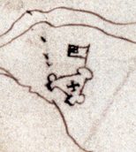
The hand-drawn James Fort derives from an intriguing 1608 map that archeologists call the Zuñiga Map. The map is named after Pedro de Zuñiga, the Spanish ambassador who had sent a copy of John Smith’s original 1608 map of Virginia from England to Spain during that same year.
The historical image of James Fort that is used as a logo for the Jamestown Rediscovery Project and Historic Jamestowne may be leading archaeologists to John Smith’s long-lost town.
A flag on the map has led to the excavation of a new site that holds promises of additional discoveries. But archaeologists remain in a race with time and the tides to uncover what John Smith wrote in his last writings regarding the layout of the town.
John Smith wrote of more than 50 houses at Jamestown in 1608, and archaeologists have yet to uncover any of these houses.
The Zuñiga map is one of the only maps that shows the exact location of James Fort.
The map also includes the surrounding landscape and waterways in addition to the triangular fort and the church inside. However, there is a peculiar feature that looks like a flag extending from the north bulwark.
This flag feature of the map was added right before it left for England in June 1608, and it was received by the Spanish sometime later that year.
For years, archaeologists thought it was just a flag. However, former Jamestown curator Bly Straube proposed that the flag could indicate an enclosure or even a garden.
SOURCE: Virginia Gazette By Dominic Catacora
James Fort is completed in a triangle shape with three bulwarks sporting artillery. Settlers also plant crops in two areas.
The Zuñiga Map
The hand-drawn James Fort derives from an intriguing 1608 map that archeologists call the Zuñiga Map. The map is named after Pedro de Zuñiga, the Spanish ambassador who had sent a copy of John Smith’s original 1608 map of Virginia from England to Spain during that same year.
The historical image of James Fort that is used as a logo for the Jamestown Rediscovery Project and Historic Jamestowne may be leading archaeologists to John Smith’s long-lost town.
A flag on the map has led to the excavation of a new site that holds promises of additional discoveries. But archaeologists remain in a race with time and the tides to uncover what John Smith wrote in his last writings regarding the layout of the town.
John Smith wrote of more than 50 houses at Jamestown in 1608, and archaeologists have yet to uncover any of these houses.
The Zuñiga map is one of the only maps that shows the exact location of James Fort.
The map also includes the surrounding landscape and waterways in addition to the triangular fort and the church inside. However, there is a peculiar feature that looks like a flag extending from the north bulwark.
This flag feature of the map was added right before it left for England in June 1608, and it was received by the Spanish sometime later that year.
For years, archaeologists thought it was just a flag. However, former Jamestown curator Bly Straube proposed that the flag could indicate an enclosure or even a garden.
SOURCE: Virginia Gazette By Dominic Catacora